[ad_1]
NEW DELHI/DEHRADUN:
Uttarakhand chief minister Pushkar Singh Dhami is holding a cabinet meeting today and may announce some important decisions regarding subsidence-hit Joshimath town in Chamoli district.
The Uttarakhand cabinet meeting is taking place after the CM’s meeting with all stakeholders on the Joshimath land subsidence issue yesterday.

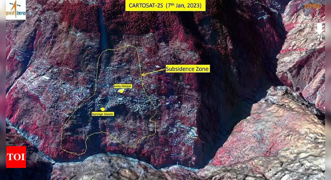
Image released by ISRO. Photo: IANS
During the meeting on Thursday, the chief minister interacted with the Army, ITBP, NDRF and scientists from various establishments engaged in landslide investigation, district administration, police and district-level officers associated with essential services at Sunil ITBP camp.
Meanwhile, the Indian Space Research Organisation’s (Isro) National Remote Sensing Centre (NRSC) in Hyderabad has released satellite images that reveal the severe land subsidence affecting the town of Joshimath. The images, taken by the Cartosat-2S satellite, show that the entire town, including the Army’s helipad and a temple, has been designated as sensitive zones.

Image released by ISRO. Photo: IANS
The preliminary report from Isro states that the land subsidence was slow between April and November 2022, during which time the town sank by 8.9 cm. However, between December 27, 2022 and January 8, 2023, the intensity of land subsidence increased dramatically, causing the town to sink by an additional 5.4 cm in just 12 days.
The Uttarakhand government is already conducting rescue operations in danger-prone areas and relocating residents to safer locations as a priority. The satellite images also indicate that the Joshimath-Auli road is at risk of collapse due to the land subsidence.
1/20
These photos capture the anger and helplessness in Joshimath
Show Captions
A woman sits beside a cracked wall of her house at Joshimath in Chamoli
Locals protest against the demolision of the unsafe hotels and houses after cracks appeared at the landslide affected area of Joshimath
As many as 131 families have been shifted to the temporary relief centres so far with 37 more evacuated on Tuesday
A resident gets emotional prior to leaving her house that have been marked unsafe by the district administration
Women break down prior to leaving their home that have been marked unsafe by the district administration
People affected by the gradual sinking of Joshimath rest at a shelter house after cracks appeared in their houses
At least 86 houses in the area have been demarcated as an unsafe zone
People shift their belongings after their houses were declared to be in the unsafe zones in view of the continued land subsidence
Hotels lean into each other as a result of the continued land subsidence
Located 82km southwest of Joshimath in Chamoli district, parts of Karnaprayag — one of the ‘panch prayags’ of Alaknanda, situated at the confluence of the river and Pindar — are “sinking” too
Repair work under way following collapse of a wall in Joshimath area
Cracks appear on stairs in Joshimath area of Chamoli district. The town has been declared a disaster-prone area after large cracks appeared in homes and on roads
Cracks appear on the road as the result of continued land subsidence in Joshimath
Locals outside the hotel where cracks have appeared as a result of continuous land subsidence
A man walks on a pathway of a building damaged due to land subsidence in Joshimath
Workers disconnect the electricity connection at the landslide affected area of Joshimath
SDRF and Nehru Institute of Mountaineering personnel inspect an area as Uttarakhand administration prepares for demolition of hotels and houses severely affected by land subsidence
Stairs of a building are severely affected due to cracks
Locals protest against the government’s decision to demolish the hotels after cracks appeared at the landslide affected area of Joshimath
Watch What satellite images reveal: All of Joshimath may sink!
[ad_2]
Source link